Thursday, December 23, 2010

Glaciers and the Cincinnati Landscape, November 25, 2010 Field Trip

This field trip was a driving tour through portions of the southeastern side of Cincinnati and Northern Kentucky to view first-hand how the glaciers sculpted the area topography and how the existing river, stream, and drainage systems are evolving to shape the landscape.  During our tour, we drove through the Clermont Valley which was cut by glacial ice and melt-water from the Illinoian glacier. The Illinoian glacial melt-water created the large system of dendritic water flows in Clermont County that are currently trying to break down the stream divides to create a larger river system to flow to the Ohio River.  We observed that as the dendritic system of water flows got closer to the Ohio River, stream divides became very small and fewer in number and the topography became choppy.  We noticed how the hilltops in the area are the peaks of where the glaciers were with the rest of the landscape sculpted through erosion. 


     When the Wisconsinan glacier moved into Northern Cincinnati about 70,000 years ago, it brought with it outwashes of sand of gravel from Canada that filled many valleys in the Cincinnati area.  As a result, there are many sand and gravel pits in the Cincinnati region and Ohio that are a valuable Ohio resource.  In the Clermont County Valley, we drove by Kipp’s and Evan’s gravel mines.  A bucket of gravel from Evan’s Gravel Mine contained gravel from the Canadian shield, dolomitic limestone, and limestone.  In addition to bringing sand and gravel, the Wisconsinan glacier carried and deposited glacial erratics from Canada into the Clermont County Valley.  Glacial erratics are large rocks mostly from the 1.5 billion years old Canadian shield.


The advance and retreat of the Illinoian glacier produced an immature soil system in the Cincinnati area.  This immature soil system consists mostly of clay and rock flower with no organic material and is classified in the world of soil orders as an Inceptisol.  Inceptisols are weakly developed young soils that are just beginning to develop a soil profile. Cincinnati’s developing soil system is affected by the immature area drainage system them continues to wash soil development.

Arch Materials Field Trip, November 2, 2010

Limestone is an abundant sedimentary rock present in the surface and subsurface bedrock strata in Ohio. Due to the high abundance of limestone, it is mined as a resource both in Ohio and in the Cincinnati area for use in the construction industry as a component of asphalt, concrete, and cement.  In fact, Ohio is a leading state in the production of limestone for use in industry. 
On our November 2, 2010 field trip, we visited an underground limestone mine in Batavia, Ohio called Arch Materials.  Wearing hard hats and gear belts, we travelled into the mine to a depth of 900 feet by truck through a “wavy” tunnel that was dug out to follow the shale line right above the limestone layer. At 900 feet below the surface, we encountered Trenton Limestone and Black River Group Limestone, which are from the middle Ordovician period (Champlainian Series) and are much older than the limestone found on surface outcrops. To mine limestone cost effectively, Arch Materials places explosives in drilled holes within the mine to blast the limestone down to a manageable size.  The "blasted" limestone can be further crushed to the desired size for use in the construction industry.

Thursday, December 16, 2010

October 19,2010 Field Trip

The October 19, 2010 field trip took us just east of Georgetown on Route 125 to a roadside outcrop of the Cincinnatian Maysvillian stratigraphic section (picture to the right).  This particular Maysvillian Stage outcrop contained rocks from the Bellevue and Fairmount Subdivisions and is composed of inter-bedded limestone and shale that contains an abundance of fossils.  At this first outcrop, the most common fossil found was the brachiopod group with Platystrophia ponderosa the most abundantly found fossil and Hebertella occidentalis the second most common fossil found (see pictures below).  In addition, other brachiopod fossils such as Rafinesquina fossils (see picture below) were found although they were not as abundant as Platystrophia ponderosa.  Bryozoan group fossils (see picture below) were also found although they did not seem to be in as great abundance as the brachiopod fossils were.  Of course after finding so many brachiopod fossils, I was determined to try to find a trilobite, but instead, I was pleased to find a cephalopod fossil  (see picture below).


Platystrophia ponderosa


Hebertella occidentalis

Rafinesquina

 
Various Bryozoans

Cephalopod (top view)


Cephalopod (x-section)


Wednesday, December 15, 2010

October 12, 2010 Field Trip

On the October 12, 2010 field trip we had the opportunity to view outcrops of the different Paleozoic surface rocks in the Cincinnati area. We travelled east on Route 32 to Keim Market, the landmark for the Ordovician/Silurian bedrock border.  The first stop near Keim Market was a roadside outcrop of Ordovician/Silurian contact.  The picture to the left shows the upper horizontal layers of the Silurian limestone (Brassfield Formation) bedrock on top of a base of Ordovician bedrock (Drakes Formation).  The talus slope contains some crumbled Silurian limestone on top of a base crumbled Ordovician shale and limestone.  The boundary between the Ordovician and Silurian bedrock is an unconformity (type: paraconformity).  An uncomformity represents a break in the rock record due to erosion or nondeposition.  On the close-up of the Silurian bedrock pictured below, chert nodules are present. Chert nodules are made of quartz (SiO2)and  are formed as precipitate from a previously chemically weathered silicate rock. In addition, crystals of the mineral, calcite were found growing on the Silurian rocks (not pictured)

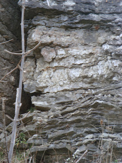
Next, we travelled further east on Route 32 to the second stop of the October 12, 2010 field trip, an outcrop of Silurian dolomitic limestone (picture to the right).  These Silurian period sedimentary rocks show tidal striations which is evidence of sedimentation in a tidal flat environment. Tidal flat sediment layers are thinly bedded and are a result of the tide coming in and going out in shallow sea water.  Sample rocks collected of these tidal flat sedimentary rocks show thin, sandy, light colored layers alternating with hard, dark colored layers (hydrocarbon or iron containing).  Pockets of light brown calcite crystals were found at various sites on the Silurian rocks.  The calcite samples were not completely white due to the presence of hydrocarbons. 
       Our last stop of the October 12 field trip took us even further east on Route 32 to an outcrop of Ohio black shale on the Hackleshin Ridge at the Devonian-Mississippi border.  At this border, the Ohio black shale from the Mississippian and Devonian periods was capped by Berea sandstone (Mississippi Period).  The sandstone sediments were transported from a blanket of sand from the Appalachians.  The tater knob, Hackleshin Ridge, was formed through weathering and erosion of the layered Devonian-Mississippi shale and Berea sandstone bedrock.  Tater knob structures are found in a ring round the Cincinnati Arch.  The picture below shows a crumbled pile of Mississippian Period Ohio black shale at the top of Hackleshin Ridge.