 On the October 12, 2010 field trip we had the opportunity to view outcrops of the different Paleozoic surface rocks in the Cincinnati area. We travelled east on Route 32 to Keim Market, the landmark for the Ordovician/Silurian bedrock border. The first stop near Keim Market was a roadside outcrop of Ordovician/Silurian contact. The picture to the left shows the upper horizontal layers of the Silurian limestone (Brassfield Formation) bedrock on top of a base of Ordovician bedrock (Drakes Formation). The talus slope contains some crumbled Silurian limestone on top of a base crumbled Ordovician shale and limestone. The boundary between the Ordovician and Silurian bedrock is an unconformity (type: paraconformity). An uncomformity represents a break in the rock record due to erosion or nondeposition. On the close-up of the Silurian bedrock pictured below, chert nodules are present. Chert nodules are made of quartz (SiO2)and are formed as precipitate from a previously chemically weathered silicate rock. In addition, crystals of the mineral, calcite were found growing on the Silurian rocks (not pictured)
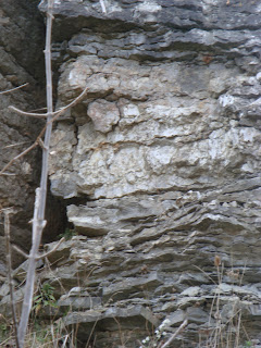
Next, we travelled further east on Route 32 to the second stop of the October 12, 2010 field trip, an outcrop of Silurian dolomitic limestone (picture to the right). These Silurian period sedimentary rocks show tidal striations which is evidence of sedimentation in a tidal flat environment. Tidal flat sediment layers are thinly bedded and are a result of the tide coming in and going out in shallow sea water. Sample rocks collected of these tidal flat sedimentary rocks show thin, sandy, light colored layers alternating with hard, dark colored layers (hydrocarbon or iron containing). Pockets of light brown calcite crystals were found at various sites on the Silurian rocks. The calcite samples were not completely white due to the presence of hydrocarbons.
Our last stop of the October 12 field trip took us even further east on Route 32 to an outcrop of Ohio black shale on the Hackleshin Ridge at the Devonian-Mississippi border. At this border, the Ohio black shale from the Mississippian and Devonian periods was capped by Berea sandstone (Mississippi Period). The sandstone sediments were transported from a blanket of sand from the Appalachians. The tater knob, Hackleshin Ridge, was formed through weathering and erosion of the layered Devonian-Mississippi shale and Berea sandstone bedrock. Tater knob structures are found in a ring round the Cincinnati Arch. The picture below shows a crumbled pile of Mississippian Period Ohio black shale at the top of Hackleshin Ridge.


No comments:
Post a Comment